BARTLETT HISTORIC SOCIETY PO Box 514 - 13 School St.
Bartlett, NH 03812


Maps: historic and current
Do You Like Old Maps?
If you like old maps this page is for you. The David Rumsey Collection includes high resolution maps for many areas and many time periods.
We have also found other historic maps from various sources.
The Harts Location Website has included an Axis-Gis map which is current. It shows property lines, owners, water and soil resources. It's a fascinating experience.

THESE WILL KEEP YOU BUSY FOR A WHILE:
1. High Quality Map of Bartlett (and other places) from the David Rumsey Map Collection; This one shows The Town of Bartlett in 1892 with many residences identified by occupant name. It shows present day Cobb Farm Road crossing the river in the area of Sawyers Rock and joining Rte 302. It shows the location of the Garland Ridge School on Stony Brook, The Hilltown School on West Side Road. Take a look and see who lived in your general area before you. This link will take you there. (unpredictable off site link, slow at times)
Bartlett Historical Society Museum has a copy of the entire Atlas from which the above map was derived...donated by George Howard of Glen.
----------------------------------------------------------------------------------------------
2. This 1796 Map shows Vere Royse and Tho Chadbourne as the principal owners of the majority of the Upper Bartlett and Harts Location Area. Click Here to see the 1796 Map. Very good resolution, zoom in to see the trees (almost).
Captain Vere Royse was a soldier and surveyor and at one time served as surveyor-general of the Province of New Hampshire. He made charter maps for many White Mountains towns, including Chatham, Bartlett and Bretton Woods. In 1769 He was granted 2000 acres near the Saco river between Glen and Bartlett; This encompassed the area from present Day Harts Location Town Line and Rogers Crossing. The land was given for his services "during the late war in North America," but Captain Royse never settled here.
The peak west of Evan Notch and nearby East Royse were named for him. The name Royse Mountain appeared on Samuel Holland's 1784 map.
Thomas Chadbourne was born in Berwick Maine,March 26, 1736, the son of William and Mary Chadbourne. His Grant of 3000 acres is part of the area today know as Harts Location. Between 1772 and 1775 Mr Chadbourne sold his grant to Richard Hart. Mr Chadbourne was also granted acreage in Conway in 1773, where he settled and built the first framed house in that town. He married Hannah Long of Portsmouth in January 1758 and fathered eight children. He died on March 7, 1810. More Information can be obtained from the book "Harts Location in Crawford Notch" by Marion L Varney published in 1997.
List of Maps We Have Found:
Map, Bartlett 1892, high resolution,
Rumsey Map GO sometimes this site is a bit persnickety
Map, Collection of 25 early maps at
WM History.org (not well maintained) GO
Map, Historic Lodging Establishments, Some From 200 Years Ago GO
Map, State, 1796 high resolution - Rumsey
Map Collection. Very detailed GO
AXIS GIS MAP _ HARTS LOCATION - INCLUDES BARTLETT. THIS IS A HIGH RESOLUTION MAP SHOWING PROPERTY LINES, WATER RESOURCES, SOIL TYPES AND MORE. IT CAN EVEN TELL YOU WHO OWNS VARIOUS ADDRESSES. A FASCINATING EXPERIENCE. THIS MAP IS PART OF THE HARTS LOCATION WEBSITE WHICH CAN BE FOUND AT THIS LINK.
MapCarta offers a large collection of satellite maps that are both zoomable and have good resolution.

Bartlett Area - 1892 -
Click the map for a large size you can see
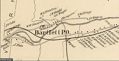


Bartlett Village to West Side Road - 1892
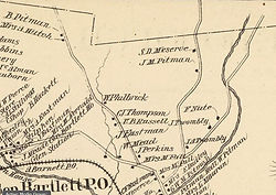
Rogers Crossing to Glen and West Side Road -1892-
Glen to the Jackson Town Line
- 1892 -
Thorn Hill Road and Dundee - 1892 -
Intervale Area -1892-
Albany Area at Bear Notch Road Terminus - 1892 -
Cobb Farm Road Showing bridge across the Saco out to route 302
- 1892 -
Bartlett Area Royse and Chadbourne Received Land Grants, 5000 acres - There Wasn't Much in the way of Neighbors...or Residents 1796
Peg Mill Area - 1910 -
Saco Valley Railroad 1892
Portland & Ogdensburg Railroad Network
- not dated -
Bartlett Map with Points of Interest...Part of map is missing
Library of Congress: Image 1 and 2 of Sanborn Fire Insurance Map from Bartlett, Carroll County, New Hampshire 1897. Click the image to go to the library and view the "zoomable" maps


There's always more to find